张翔,男,1969年生,教授、博士生导师,1998年于四川大学获水文水资源博士学位。现任水文水资源实验研究中心主任,兼任中国自然资源学会理事、水资源专业委员会委员、湿地资源保护专业委员会委员,中国可持续发展研究会水问题委员会委员。
本页面主要目录有关于张翔的:人物经历、主要成就、获奖记录等介绍

张翔,男,1969年生,教授、博士生导师,1998年于四川大学获水文水资源博士学位。现任水文水资源实验研究中心主任,兼任中国自然资源学会理事、水资源专业委员会委员、湿地资源保护专业委员会委员,中国可持续发展研究会水问题委员会委员。
本页面主要目录有关于张翔的:人物经历、主要成就、获奖记录等介绍
中华人民共和国
1969年
教师
教授、博士生导师
水文水资源实验研究中心
四川大学
博士
张翔
男
教育部科学技术进步一等奖和自然科学二等奖
1990年7月 毕业于东华理工学院水文地质与工程地质专业(本科)
1993年7月 长安大学水文地质专业研究生毕业,获硕士学位 1997年11月 四川大学水文水资源专业研究生毕业,获博士学位。
1998年4月-2000年6月 武汉大学土木水利博士后流动站博士后,
2000年6月至2013武汉大学水利水电学院,副教授,
2002年1—2月于香港中文大学访问研究,
2003年8月—2004年2月在澳大利亚墨尔本大学访问学者。兼任中国自然资源学会水资源专业委员会委员,国际水文科学协会(IAHS)会员。
研究方向
1.系统水文学:流域水文过程的计算智能模拟。

2. 可持续水资源管理。
3. 水环境模拟。
科研项目
1. 湖北省水利厅科技专项:沮漳河猴子岩流域洪水预报模型研究; 2. 中山大学:广州市洪奇沥水道水污染控制研究; 3. 中国科学院知识创新项目子题:陆气水循环与水资源风险研究,KXCX-SW-317,; 4. 中国科学院知识创新项目子题:变化环境水循环模拟与影响分析研究,CX10G-E01-08; 5. 中山大学:广东省三防指挥系统勘察设计; 6. 全国防洪规划研究专题研究:防洪标准与洪水风险研究——洪水灾害评估与防洪标准比较研.
论著
Tinghua Ai, Xiang Zhang, Qi Zhou and Min Yang (2015). A vector field model to handle the displacement of multiple conflicts in building generalization. International Journal of Geographical Information Science, 29(8): 1310-1331. (SCI)
Tinghua Ai, Min Yang, Xiang Zhang and Jing Tian (2015) Detection and correction of inconsistencies between river networks and contour data by spatial constraint knowledge. Cartography and Geographic Information Science, 42(1): 79-93. (SCI)
Xiang Zhang and Tinghua Ai (2015). How to model roads in OpenStreetMap? A method for evaluating the fitness-for-use of the network for navigation. In: F. Harvey and Y. Leung (eds.), Advances in Spatial Data Handling and Analysis, Advances in Geographic Information Science, Lecture Notes in Geoinformation and Cartography, Springer, 143-162. (Book Chapter)
Xiang Zhang, Tinghua Ai, Jantien Stoter, Xi Zhao (2014) Data matching of building polygons at multiple map scales improved by contextual information and relaxation. ISPRS Journal of Photogrammetry and Remote Sensing, 92: 147–163. (SCI)
Tinghua Ai, Qi Zhou, Xiang Zhang*, Yafeng Huang and Mengjie Zhou (2014) A simplification of Ria coastline with geomorphologic characteristics preserved. Marine Geodesy, 37:167–186 (SCI)。
Xi Zhao, Alfred Stein, Xiang Zhang, Lian Feng, Xiaoling Chen (2014) Variation analysis of lake extension in space and time from remote satellite images using random sets. International Journal of Applied Earth Observation and Geoinformation, 30: 86-97, 2014. (SCI)
Jantien Stoter, Xiang Zhang, Hanna Stigmar and Lars Harrie (2014) Evaluation in Generalisation. In: D. Burghardt et al. (eds.), Abstracting Geographic Information in a Data Rich World, Lecture Notes in Geoinformation and Cartography, pp. 259-297. (Chapter in ICA Book Series)
Xiang Zhang, Jantien Stoter, Tinghua Ai, Menno-Jan Kraak and Martien Molenaar (2013) Automated evaluation of building alignments in generalized maps. International Journal of Geographical Information Science, 27(8): 1550-1571. (SCI)
Xiang Zhang, Tinghua Ai, Jantien Stoter, Menno-Jan Kraak, and Martien Molenaar (2013) Building pattern recognition in topographic data: examples on collinear and curvilinear alignments. GeoInformatica, 17(1): 1-33. (SCI)
周启, 艾廷华, 张翔 (2013) 面向多重空间冲突解决的移位场模型. 测绘学报, 42(4): 615-620. (EI)
Xiang Zhang, Xi Zhao, Martien Molenaar, Jantien Stoter, Menno-Jan Kraak, Tinghua Ai (2012) Pattern classification approaches to matching building polygons at multiple scales. In M. Shortis, J. Shi, E. Guilbert (eds.): ISPRS Annals (ISPRS Congress 2012), Melbourne, Vol. I-2, pp. 19-24 (Invited Oral)。
Xiang Zhang, Tinghua Ai, and Jantien Stoter (2012). Characterization and detection of building patterns in cartographic data: Two algorithms. In Advances in Spatial Data Handling and GIS, Lecture Notes in Geoinformation and Cartography, Springer, pp. 93-107. (Book Chapter)
Xiang Zhang, Jantien Stoter, Tinghua Ai, and Menno-Jan Kraak (2012). Formalization and data enrichment for automated evaluation of building pattern preservation. In Advances in Spatial Data Handling and GIS, Lecture Notes in Geoinformation and Cartography, Springer, pp. 109-125. (Book Chapter)
Xi Zhao, Alfred Stein, Xiaoling Chen and Xiang Zhang (2011) Quantification of Extensional Uncertainty of Segmented Image Objects by Random Sets. IEEE Transactions on Geoscience and Remote Sensing, 49, pp. 2548-2557. (SCI)
Xiang Zhang, Tinghua Ai, and Jantien Stoter (2009) A Voronoi-like model of spatial autocorrelation for characterizing spatial patterns in vector data. In Proceedings of the 2009 Sixth International Symposium on Voronoi Diagrams (ISVD’09), pp. 118–126, Washington, DC, USA, 2009. IEEE Computer Society. (EI) (Oral presentation)
Xiang Zhang, Tinghua Ai, and J. Stoter (2008). The evaluation of spatial distribution density in map generalization. In International Archives of the Photogrammetry, Remote Sensing and Spatial Information Sciences (ISPRS Congress 2008), volume XXXVII. Part B2., pp. 181–188, Beijing. (Oral Presentation)
Xiang Zhang, Jantien Stoter, and Tinghua Ai (2008). Formalization and automatic interpretation of map requirements. In The 11th ICA Workshop on Generalisation and Multiple Representation, p. 12, Montpellier, France. (Oral Presentation)
Tinghua Ai and Xiang Zhang (2007). The aggregation of urban building clusters based on the skeleton partitioning of gap space. In S.I. Fabrikant and M. Wachowicz (eds), In The European Information Society: Leading the Way with Geo-information (AGILE07), Lecture Notes in Geoinformation and Cartography, pp. 153–170. Springer, Aalborg, Denmark. (Book Chapter)
Xi Zhao, Xiaoping Pang, Shengli Zhang and Xiang Zhang (2007) Unification and Harmonization in True Color Image City Map. Geo-Spatial Information Science, 10(1): 75-78.
庞小平, 赵羲, 高峰, 张翔 (2006) 真彩色城市影像地图统一协调性研究, 武汉大学学报(信息科学版)31(6): 481-483. (EI)
1. “水文非线性系统理论与方法研究”,2004年湖北省自然科学一等奖(排名第三)。
2. 2002年优秀班主任。
2006年第一届武汉大学双语教学竞赛三等奖。
2007年度武汉大学水利水电学院本科教学优秀个人二等奖。
2021年11月,张翔副教授参与的科研项目“智能化地图综合与多尺度级联更新关键技术及应用”获国家科技进步奖二等奖。

新亚洲娱乐(英文名:ASIA ENTERTAINMENT GROUP LIMITED,全称:新亚洲娱乐联盟集团有限公司)是一家以从事戏剧制作人及杂项戏剧服务为主的企业,成立于1999年,位于香港特别行政区。旗下分公司包括虎威艺能创作有限公司(TGS HK)、稻草人娱乐创作社(Scarecrow Entertainment)、虎威王朝音乐创作股份有限公司(TGS Music)、虎威活力娱乐传播有限公司(TGS Taiwan)、AK Entertainment(Korea)以及AEG Korea等。
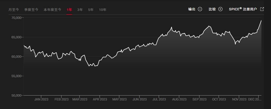
印度孟买SENSEX30指数(又称孟买敏感指数)为印度最被广泛使用的指数,为投资印度的重要参考指标,是由孟买证券交易所发行。由于各类媒体提到的“印度股市”,实际上都是孟买股票交易所,因此,该交易所的SENSEX-30指数几乎成了印度股市的代名词。